

Pietro Miotti Uses 48 AI Agents to Rediscover Maya Site in 72 Hours

- Reading
- 6 min
Personal blog author describes how he directed 48 artificial intelligence agents to scan NASA lidar data and flag a Maya site outside the official registry of Mexico's National Institute of Anthropology and History (INAH), until discovering that archaeologists had already mapped it before.
Between October 18 and 21, Pietro Miotti set 48 agents to scan NASA lidar data over the Maya jungle. They found a site outside Mexico's official registry, but it had already been mapped by archaeologists before.
Between October 18 and 21, 2026, Pietro Miotti used 48 artificial intelligence agents to scan NASA lidar images over the Maya region in Mexico and locate, in under 72 hours, an archaeological site that was not listed in the country's official registry at the National Institute of Anthropology and History (INAH). On November 11, Miotti updated his own account, published on his personal blog: researchers had already mapped the same location in a 2025 study (Estrada-Belli et al.), except the finding had not yet entered INAH's public registry. He calls the episode a "rediscovery," not a discovery.
How the Agents Scanned 1,200 km² of Jungle
The idea came from a comparison: Miotti was traveling through Peru and remembered Hiram Bingham, the explorer who reached Machu Picchu in 1911 while looking for another city. He asked four different agents, Gemini, ChatGPT, Claude and Grok, what tool Bingham would use today. The unanimous answer was lidar: the sensor fires laser pulses that pass through gaps in the tree canopy and map the terrain's relief, while a regular satellite photo only shows forest.
With Peru poorly covered by public data, the choice fell on the Maya region, well mapped by open lidar data. The agents converted the lidar swaths, about 1,200 km² of jungle, into images and spent the night examining them one by one, like patient archaeologists following a script written by Miotti to recognize pyramids, platforms and plazas and rule out natural hills, sinkholes and roads. There was no trained classifier or specialized vision model: it was parallel image reading, pure and simple, just at scale.
For those who design data pipelines, the detail that stands out is exactly this: no model training step at all. The work was distributed across 48 instances of general-purpose agents running the same instruction over different slices of the same dataset, a pattern similar to map-reduce, except the "map" is an agent reading an image and deciding whether it looks like a ruin.
From the Pile of Shapes to the First Alert
By the next morning, the agents had already flagged dozens of regular shapes, villages and possible structures. Miotti then asked them to cross-check that list against academic literature and official records, to separate what was already known from what wasn't. Hours later, came the answer: a large settlement appeared to be unregistered.
The location sits atop a hill, on the edge of a cliff, beneath the tree canopy, with straight corners and edges that nature rarely produces on its own. In the lidar reading, it's possible to make out a leveled plaza, an oval pyramid 8 to 12 meters tall, an elevated courtyard connected to it, and a flat-bottomed depression that may have been a water reservoir.
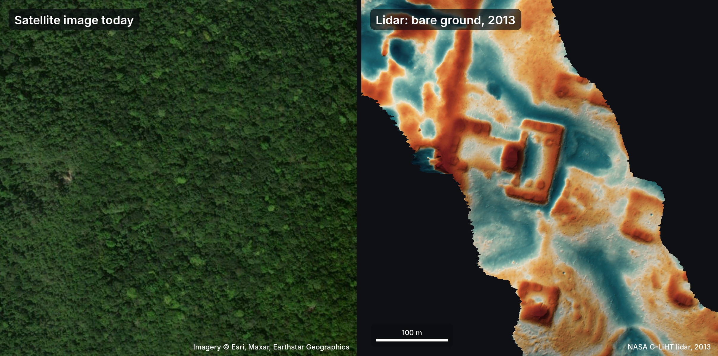
The interpretation, according to the agents themselves and without archaeological confirmation, is that of a small Maya civic center from the Classic period (between 250 and 900 A.D.), a kind of "downtown" for a local elite, with the pyramid serving as a temple and the courtyard as a ruler's residence.
The Check That Avoided the Bigger Mistake
On October 19, the agents guided Miotti on how the site-reporting process works in Mexico and pointed him to INAH's contacts so he could send a report about the finding.
The next day, while iterating on the report, the agents also checked the lidar's raw point cloud, not just the processed image, to confirm the shapes really came from the ground and not from an artifact created by vegetation. Green points marked leaves, brown points marked the ground: under 10 to 17 meters of forest, the brown terrain clearly outlined the plaza, the pyramid and the courtyard. Since Miotti doesn't speak Spanish, one of the agents (Claude) suggested translating the entire document to increase the chance of a response, and he followed the recommendation, trusting the agent. Only then was the report sent to INAH.
The next day, INAH replied that there was no registered site at those coordinates:
...no registered archaeological site was identified at the location given in your report.
National Institute of Anthropology and History (INAH), in official response to the report
It was only in the November 11 update that Miotti acknowledged the interpretation error: the site had already been mapped by archaeologists in the study by Estrada-Belli and colleagues, published in 2025 on settlements across the entire Maya lowlands. It simply wasn't yet in the public database that INAH consulted. The agents, according to the account itself, overlooked that reference while scanning the literature.
What Changes for Those Who Work with Large Datasets
The episode isn't about archaeology, and Miotti himself makes a point of saying so:
I'm not an archaeologist, so I didn't know this was supposed to be hard. I just picked an old problem, tried the most obvious thing and threw some compute at it. Being a naive outsider might be a superpower now.
Pietro Miotti, on his personal blog
For those doing product discovery or dealing with datasets too large for manual review, there are concrete takeaways from the account:
- Parallelizing doesn't require a new model. The 48 instances ran the same visual prompt over different slices of the same giant image, without training anything specific for the task.
- Triangulating with different models reduces bias. The choice of method (lidar instead of satellite) only emerged because four agents from different providers (Gemini, ChatGPT, Claude, Grok) converged on the same answer.
- Validate against the raw source before acting. The difference between reporting a real finding and a visual artifact was checking the original point cloud, not relying solely on the image already processed by the agent.
- The prompt is the product. The entire outcome depends on the written script that instructed the agents to recognize straight lines, corners and geometric patterns as a sign of an artificial structure.
What Still Remains Open
Miotti himself treats the site's interpretation as speculation: pyramid, courtyard and reservoir are readings made in conversation with the agents, without an archaeologist's validation. The correction published on November 11 shows the method's real limit: the agents got it wrong when scanning the academic literature and missed exactly the study that already contained the site.
It also remains open whether the trick generalizes: what worked here depends on a strong visual signal (straight lines and corners don't occur by chance in nature) and on a dataset that is already open and well documented, like the lidar data for the Maya region. Miotti ends the account by suggesting scaling the idea: mapping the entire planet with lidar and letting agents scan the rest. For now, it's a working hypothesis, not a reproduced result.
Translated from the Brazilian Portuguese original · Read the original

Human remains accountable even when AI writes the code, says Hugo Venturini
In an InfoQ podcast, engineer Hugo Venturini argues that AI doesn't create a new accountability problem in code: it exposes one that already existed, and it's up to team culture to solve it.